Smoke from wildfires or controlled burns contains water vapor, carbon dioxide, and harmful fine particles like PM2.5, which can impact health. The severity of effects depends on exposure duration, smoke concentration, and weather conditions.
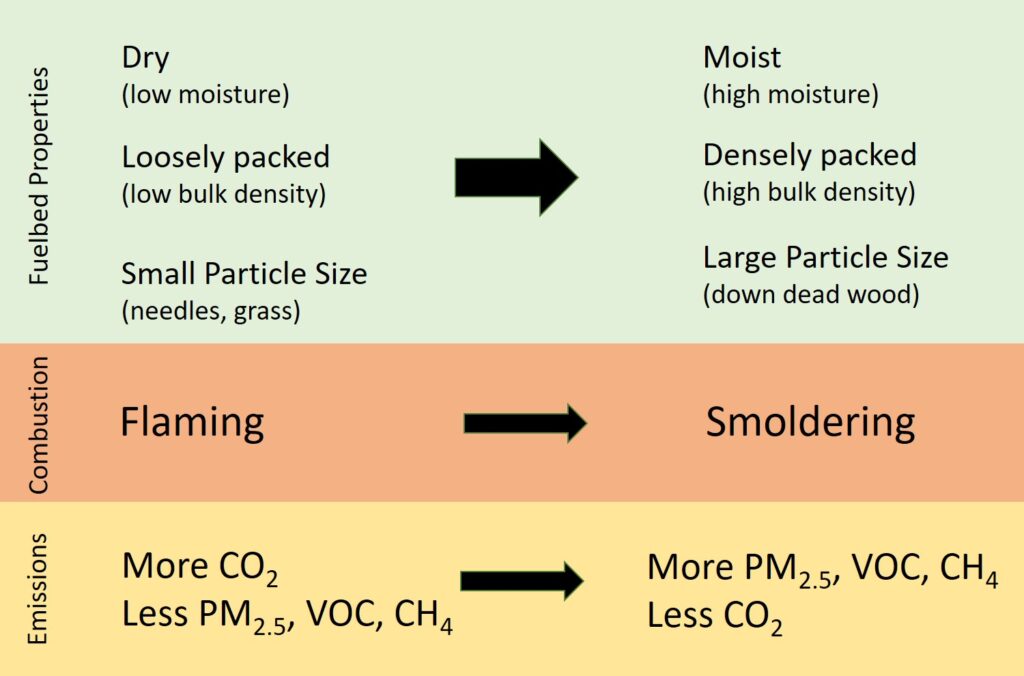
Smoke is a byproduct of the fuels consumed by fire. In a wildfire or prescribed fire, fuels can include living and dead vegetation and organic soil. Smoke is primarily made up of water vapor and carbon dioxide (CO2), which are the products of complete combustion. Typically, more than 90% of the carbon in vegetation and soil that is released into the atmosphere by wildfires is in the form of CO2. However, smoke also contains hundreds of other gases and particles that are diverse in size and composition. It is these other gases and particles that are responsible for the harmful effects of smoke. In particular, the very small liquid droplets and solid particles referred to as fine particulate matter (also called PM2.5) are especially detrimental to human health. Wildfire smoke has been shown to have detrimental respiratory and cardiovascular health effects and causes increases in mortality and morbidity. The severity of health impacts from smoke depends on exposure. Exposure is measured by the smoke’s concentration and duration. Exposure in a given area is related to how much fuel is being burned, the composition of the smoke, the location of the fire(s), the plume dynamics of the fire(s), and the atmospheric conditions that determine how smoke is dispersed and transported.
Limiting exposure to wildfire smoke is the best action available to reduce negative public health impacts. Observations of current and recent PM2.5 concentrations and forecasts of smoke impacts on future PM2.5 concentrations are essential for informing the public and guiding strategies to reduce smoke exposure. Observations of PM2.5 concentrations are provided by regulatory air monitoring networks, temporary measurements by teams that respond to wildfires, and a growing informal network of low-cost PM2.5 sensors operated by the public and a range of government entities. Smoke forecasting systems—which are models that integrate composition, emissions, and atmospheric transport—are used to predict PM2.5 concentrations resulting from wildfires.
Wildfire smoke can be a serious threat to human health. In general, the severity of health impacts from smoke depends on both the concentration and duration of exposure. While smoke forecasting systems can predict pollutant concentrations resulting from wildfires, these forecasts are often highly uncertain due to complexity of the fuels-fire-atmosphere processes that produce and transport smoke. Therefore, real-time measurements of surface-level PM2.5 are needed to support activities that can directly or indirectly protect the public from the health and safety hazards of wildland fire smoke. These activities include air quality forecasting, issuing guidance to the public for limiting smoke exposure, managing prescribed fires to reduce smoke impacts, monitoring the exposure of wildland firefighters to PM2.5, estimating population-level exposure to PM2.5 in retrospective health studies, and the development and validation of smoke modeling systems.
The primary source of PM2.5 observations are regulatory air monitoring sites, which are limited in number and concentrated in urban areas and do not provide adequate coverage to characterize wildland fire smoke impacts. In the 12 western U.S. states there are only ~ 300 regulatory monitoring sites providing hourly observations of PM2.5. Most rural communities susceptible to wildland fire smoke are without regulatory monitors. Existing air pollution monitoring networks do not satisfactorily measure smoke impacts and leave rural populations without adequate public health information. In response to concerns about smoke exposure, federal, state, and local agencies have initiated efforts to provide non-regulatory monitoring of smoke impacts during the wildfire season and during prescribed burn operations. Recently, PM2.5 monitors that are low-cost and require minimal technical expertise to use have become widely available. There is a growing informal network of these low-cost PM2.5 sensors operated by the public and a range of governmental entities which is greatly expanding the monitoring of smoke impacts.